Seismic Survey: An Important Technique for Oil and Gas Exploration
Seismic survey is a key non-destructive technique used for oil and gas exploration. It involves using seismic waves to image the geological structures underground. With advanced seismic techniques, geologists can now look deeper below the earth’s surface than ever before to map oil and gas reservoirs.
What is a Seismic Survey?
A seismic survey is a method used to image the subsurface of the earth by creating and recording seismic waves artificially induced into the earth and studying their responses. Seismic waves are generated by shaking or vibrating the earth’s surface through an energy source. Common sources include dynamite, vibrator trucks or air guns. The shaking results in seismic waves that travel into the earth’s interior, get reflected at interfaces between rock layers having different properties and return to the surface. These returning waves are sensed through receivers called geophones placed on the ground or in boreholes. The arriving waves are analyzed and processed to map variations in lithology, structure and fluid content below the surface.
Mapping Geological Structures
Recording the arrival times of seismic waves at multiple locations allows mapping the variations in subsurface geology. By analyzing differences in arrival times of waves reflecting from interfaces, geologists can interpret the depth, dip and shape of rock layers like sedimentary basins, faults, oil and gas reservoirs. Key geological structures identified through seismic techniques give clues about possible traps for hydrocarbons. Using seismic data, geologists can identify anticlines, synclines, growth faults and channel fills which may have trapped oil and gas over geological time.
Imaging Subsurface Rock Properties
Seismic waves travel at different velocities through rocks depending on their type, pore fluid content and other physical properties. The velocity variations lead to different acoustic impedances at layer interfaces. By analyzing changes in amplitudes of reflected seismic waves, geophysicists can estimate subsurface rock properties and fluid saturations. This allows identifying potential reservoir intervals with high porosity and fluid saturation like hydrocarbon bearing sands. Seismic attributes maps help differentiate lithologies like shales from porous reservoir rocks. This information helps delineate drillable prospects in Exploration & Production activities.
Challenges in Complex Geological Settings
While seismic provides a powerful tool for subsurface imaging, its effectiveness varies with geology. Seismic resolution and accuracy depends on contrasts in acoustic impedances of rock layers. In areas with minimal lithological variations like clastics with subtle facies changes or carbonates with patchy porosity distribution, imaging becomes challenging. Also, complex structural styles with intense fracturing or folding often make seismic interpretation difficult. Advanced seismic techniques with dense coverage and full Azimuth surveys along with integration with well data helps address such difficulties to some extent. Still, seismic mapping abilities remain limited in highly deformed or lithologically ambiguous geological terrains.
Time-Lapse or 4D Seismic Monitoring
4D or time-lapse seismic involves repeat surveys over producing oil & gas fields to monitor reservoir changes over time. By comparing multiple 3D seismic volumes acquired at different time periods, engineers can track fluid movement inside reservoirs. This helps improve recovery from mature fields through infill drilling or enhanced oil recovery methods. Time-lapse data helps visualise changes in fluid contacts, pressure fronts, fluid saturation or compaction profiles due to production. Such techniques enable optimizing field development plans, reservoir management and estimating producing field reservoir volumes more accurately.
Sub-Seafloor Surveys for Offshore Exploration
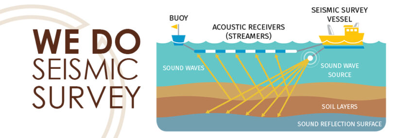
Special marine seismic techniques are used for offshore petroleum exploration where deposits exist below thick water bodies. High energy seismic sources like airgun arrays generate intense sound impulses that penetrate beneath seabed sediments. Receivers including ocean bottom cables and node deployments on seafloor record the returning signals. Advanced techniques deploy source arrays from seismic vessels in precise geometries to image complex fold-thrust structures, salt bodies and deep-water turbidite reservoirs. Towed streamers behind vessels help map seafloor topography and shallow geologic features. Complex imaging is also conducted for offshore permafrost or gas hydrates assessments.
With continuous innovations, seismic methods have become a mainstay of hydrocarbon exploration over the last few decades. Advances like denser coverage, wide-azimuth acquisitions, broadband recording and full waveform inversion are pushing the frontiers of seismic resolution. Integration between seismic interpretation and other data like boreholes, production history, geology is key to unlock hydrocarbon potential in diverse geological domains. Looking ahead, emerging technologies show promise to extend seismic mapping capabilities into previously challenging geologic terrains and help explore deeper reservoirs, both onshore and offshore.
Note:
1. Source: Coherent Market Insights, Public sources, Desk research
2. We have leveraged AI tools to mine information and compile it

